Alberta Groundwater Resources
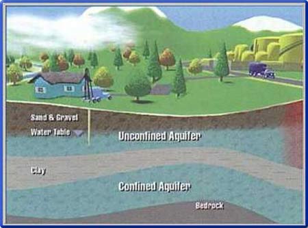
Groundwater is an integral part of the hydrological cycle [i] and contributes to stream flows and lake levels. It is also an important drinking-water supply for over 600,000 Albertans. The following is a list of resources that may be of use in continuing research on the topic of groundwater.
Groundwater Mapping and Inventory Program
The Alberta Geological Survey (AGS) runs several groundwater research programs to do with saline and non-saline water systems [ii]. The AGS also has multiple publications and datasets [iii] hosted online.
Compilation of Alberta Groundwater Information from Existing Maps and Data Sources
In 2007, AGS and Alberta Environment staff gathered the available digital datasets, PDF files, and hard-copy maps from the internal and external sources listed above to create an initial view of the extent and nature of groundwater resources in Alberta. The Compilation of Alberta Groundwater Information from Existing Maps and Data Sources report provides details on the data used, the limitations of the data, and any assumptions made during the creation of the products.
Water Wells That Last
The “Water Wells … that last” guide [iv] contains information to help owners better understand and manage rural water well systems. Topics include planning your water system, designing and constructing water wells, monitoring water wells, and more.
Groundwater Observation Well Network (GOWN)
The Groundwater Observation Well Network (GOWN) [v] is a network of some 306 groundwater wells that monitor groundwater levels in aquifers across Alberta. Some wells in the network also monitor a variety of groundwater quality parameters. Using this page, you can access the historical groundwater level information for the active wells in the network.
The network has expanded for better provincial coverage and still includes clusters of wells around highly industrialized areas, such as Fort McMurray. Regional technologists and Alberta Environment staff in Lethbridge, Calgary, Edmonton, and Grande Prairie maintain the wells, download data, take manual readings, and archive the data into Alberta Environment’s GOWN database. The Alberta Groundwater Information Centre checks the data and maintains the GOWN database.
Alberta Water Well Information Database
The Alberta Water Well Information Database [vi] displays an interactive map that has been overlaid with water well drilling reports and baseline water well test reports. Additionally, wells may be searched for in the province. Hint: zoom into the specific area you are interested in to have the well sites displayed.
Sources:
[i] Groundwater Foundation, n.d., The Hydrologic Cycle. https://groundwater.org/hydrologic-cycle/. Accessed 2023-05-09.
[ii] Alberta Geological Survey, n.d., Groundwater Geoscience Program. https://ags.aer.ca/research-initiatives/water-resources. Accessed 2023-05-09.
[iii] Alberta Geological Survey, n.d., Report Series Descriptions. https://ags.aer.ca/products/report-series-descriptions. Accessed 2023-05-09.
[iv] Government of Alberta, 2019, Water Wells … that last. https://open.alberta.ca/publications/9781460143414. Accessed 2023-05-09.
[v] Government of Alberta, n.d., Groundwater Observation Well Network. https://www.alberta.ca/lookup/groundwater-observation-well-network.aspx. Accessed 2023-05-09.
[vi] Government of Alberta, n.d., Alberta Water Wells. http://groundwater.alberta.ca/WaterWells/d/. Accessed 2023-05-09.